Where Is What in Northstar? A City Atlas
Listen to this post10 min
Created by AI from the text of this post and read by a synthetic voice; not a word-for-word version, and it may contain errors.
Loading…
Created by AI from the text of this post and read by a synthetic voice; not a word-for-word version, and it may contain errors.Position and speed stay in this browser and are sent nowhere.
The recording could not be played. Open the audio file
Northstar's building and traffic reports use names such as Westfeld, Seeviertel, Osttor and Südraum. Without a shared overview they stay abstract. This atlas places the main areas in space, from the older northern city through the western extensions to the eastern city and the southern residential areas.
Three sketches show the stored road and rail network from above. North is at the top, west on the left, east on the right, south at the bottom. Numbered points mark documented location anchors or tile centres, not official district boundaries, and the numbering applies within each sketch.
The network underlying the sketches belongs to the documented citywide survey of 2 October and is assembled from several queries; the stored network files contain no exact individual times. The new residential areas placed here are documented up to 2 October as well. The sketches are therefore a dated orientation aid, not a live map. They were reviewed editorially on 3 October 2026.
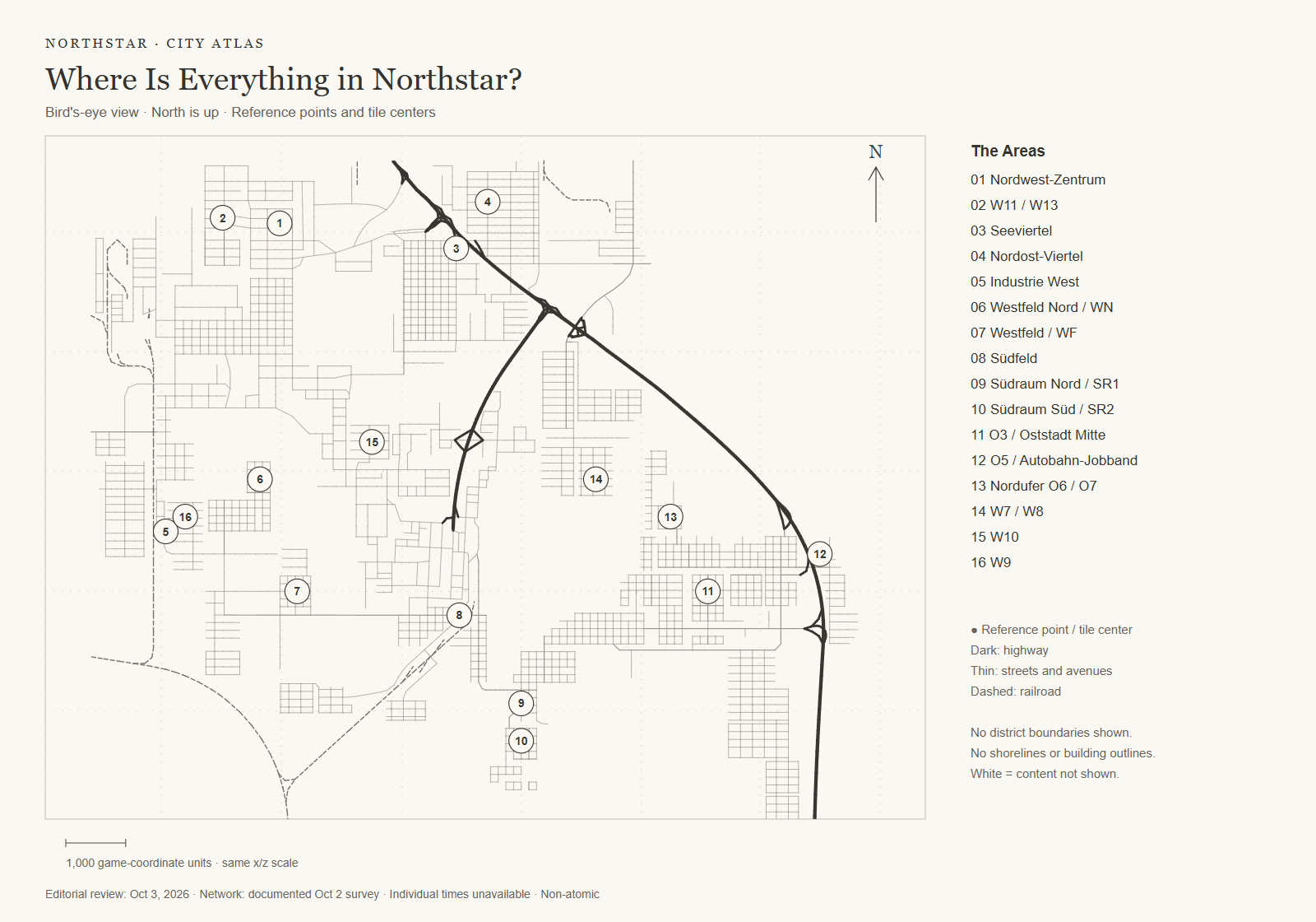
The north: connected reference points
The Nordwest-Zentrum lies in the upper left of the overview. The newer residential districts W11 and W13 adjoin it to the west, with W13 south of W11. Further east follow the Seeviertel and the Nordost-Viertel. These names help place reports on densely built areas, service coverage and public transport expansion.
The Seeviertel has documented road and rail reference points in the northern city. Its name does not replace a drawn lake boundary, though: this map base lacks suitable geometry for a reliable shoreline, so the terrain is deliberately left blank in the sketches.
Street names can be placed too. Fürstenstraße is a reference point of the Nordost-Viertel. Further west, in the western grid by the railway, lie the Wiesenstraße, Villenstraße and Schwarzdornstraße covered in traffic reports. "Western congestion section" refers in these cases to one specific stretch of road, not automatically to all of Westfeld.
The west: telling industry and housing apart
Industrie West, Westfeld Nord and Westfeld are different reference points. The industrial anchor marked in the overview lies on the western edge, west of W9. Other documented western industrial and traffic areas extend further north, so the point is neither the boundary nor the centre of all western industry.
Westfeld Nord, short WN, lies east of the western industrial anchor and north of Westfeld, short WF, which is further south. The newer W9 lies west of WN, near the western industrial surroundings. That proximity explains why site reports treat residential areas and office strips separately there. The sketch documents location; it shows no protection or emission boundary of its own.
W10 lies between the western and northern city. A post about W10 therefore concerns a different site than one about WN, even though both lie west of the large eastern extensions.
The south: Südfeld, SR1 and SR2
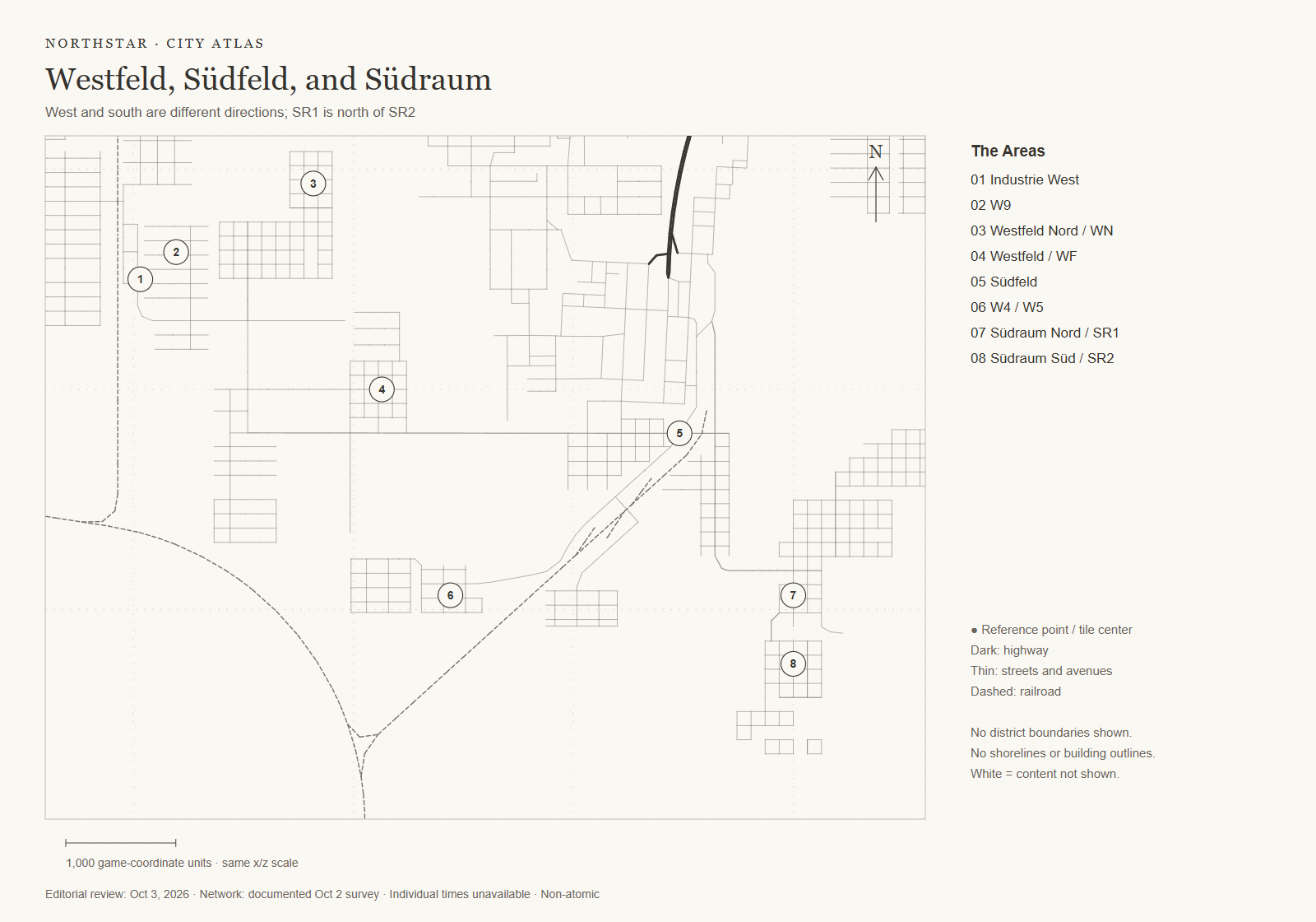
Südfeld lies south of the older northern city and east of Westfeld. Its traffic reports focus on Heinestraße, Veilchenstraße and Seeuferstraße. Heinestraße provides a documented access anchor; bottlenecks there belong to the transition between the existing city and the southern extensions.
Further south-east follows SR1, called Südraum Nord in planning, and further south SR2, the Südraum Süd. "Nord" in SR1 is relative: SR1 lies north of SR2 but still in the southern part of the drawn city. That differs from the Nordwest-Zentrum or Nordost-Viertel.
West of these Südraum sites lie the newer residential districts W4 and W5. In the detail map the shared point marks the tile centre of W4; W5 lies west of it. The drawn road segments add orientation without claiming the state of individual houses or their occupancy.
The east: from O1 to the motorway job belt
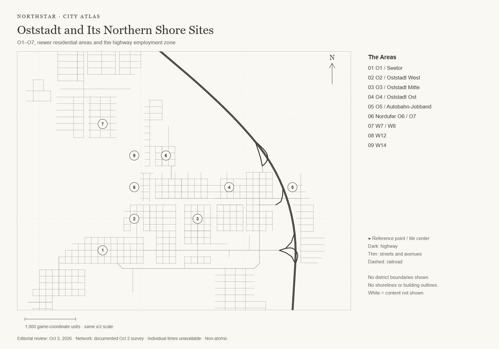
The Oststadt (eastern city) begins east of Südfeld. Its working names form a readable sequence: O1 and O1a at the Seetor, O2 as the western part of the Oststadt, O3 in its middle and O4 further east. O5 is the Autobahn-Jobband Ost (eastern motorway job belt), with documented later re-designations of individual office areas. "Oststadt West" thus means the western part of the Oststadt, not the west of the whole city.
North of it lie the Nordufer sites handled under O6 and O7. The later execution uses O7 for one stage on the north shore. These names are working labels from different planning and construction phases and do not form a consistently unambiguous district register.
The newer residential districts W7 and W8 lie north of the central Oststadt sites, with W8 west of W7. W12 and W14 lie further east around the Nordufer, W14 north of W12. Their numbered points refer to documented tile centres; the actual street grid may lie to one side.
The dark motorway line on the eastern edge helps place reports on Osttor and motorway junctions. The Südtangente Ost runs along the southern edge of the Oststadt and connects documented sites from O1a towards the eastern axis. Zypressenstraße appears in traffic reports in the eastern junction area. Expanding a junction and improving traffic are different statements; the sketch alone shows no relief.
Reading later reports
| Name in a report | Spatial placement |
|---|---|
| Nordwest-Zentrum, Seeviertel, Nordost-Viertel | Northern city; read from left to right, west to east |
| WF and WN | Westfeld and Westfeld Nord, which lies north of it |
| Südfeld, SR1, SR2 | Südfeld at the Heinestraße access; SR1 further south-east, SR2 south of SR1 |
| O1/O1a to O5 | Oststadt from the Seetor to the eastern motorway job belt |
| O6/O7, W12, W14 | Nordufer surroundings of the Oststadt; different working and construction-phase labels |
| W4, W7, W9, W14 and other W numbers | Numbered residential districts; the W is not a compass direction |
The sketches stay schematic. Street curves are simplified as connections between stored endpoints. Two lines crossing on paper prove neither a junction nor the same level. Building footprints, vegetation and water outlines were not added. The maps show the documented spatial order without turning unknown areas into a supposed city state.
The three sketches can be reused in coming articles: the overview as an opening, the sections beside posts on eastern or south-western sites. Date, legend and limits should be kept. New streets or area names need a verified update, so that today's atlas does not quietly become a seemingly current map. For the project itself, see CS2.
Sources and limits of the depiction
The basis is stored citywide network read-backs from the documented survey of 2 October, the site portfolio of 29 September and later construction and result logs up to 2 October. Orientation follows the documented map with north at the top. All network windows used are marked as complete in the stored results; this implies neither complete coverage of the whole game world nor a simultaneous snapshot. The spatial illustrations and their cleaned geometry data are delivered separately and do not change the existing contract for daily, performance or chart data.